 |
A Regional View of WaterTeacher page - Global Lab In this activity, students place their local body of water in the context of its watershed. |
|
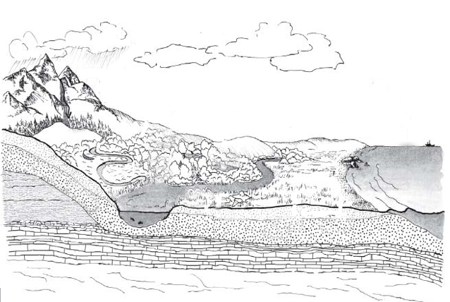
Activity-at-a-GlanceStudents consider their body of water in a regional context. "What is a watershed? "A watershed is an area of land that collects and directs water that falls on a surface and percolates into the ground toward a stream or surface water body, where it evaporates to the atmosphere. All land is located within some type of watershed; therefore all proposed land uses occur within a watershed." - Shirley Griffin, teacher and author, Ashburnham , MA |
Classroom Management and PreparationThe beginning of this activity is designed for student teams, finishing with a class discussion. Step 3 (The GL Watershed) could be done in class. The more maps and images you can locate, the better, and the number of student teams in Step 1 will depend on the variety of maps you are able to collect and the age and interest of your students. Map Questions references a watershed map, a topographic map, a map locating the source of your drinking water, and a map of the sewage system in your area. If such maps are not available, or if you have different maps, you may need to adapt the Map Questions accordingly. |
Recommended Procedures1. Have student teams examine one or more water maps and their map questions. Maps that might be included here:
The goal is to have students share information in order to interpret the nature of their study site and their local body of water. This portion of the activity is adapted, with permission, from Cole-Misch, Sally, Larry Price, and David Schmidt, eds., Sourcebook for Watershed Education (Dubuque, IA: Kendall/Hunt, 1996). 2. Have student teams report and discuss their findings about their own watershed and how it might impact their body of water. As student teams report their answers to the Map Questions, the class can build a list of features that might have an impact on their body of water. 3. Have students place themselves on the Watershed outline. What features of the watershed outline might they change to make the placement more correct? Students can extend the activity by locating other Global Lab schools on the virtual watershed, perhaps writing and asking them if they are not sure. 4. Share findings with other interested schools. |