Latitude and Longitude
The Grid
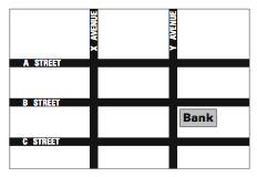
What if you had to tell visitors how to find their way to a bank? You might tell them, "Well, it’s at the corner of B Street and Y Avenue."
The pattern of streets makes a grid, which you can use to locate particular places. Each line on the grid (in this case, each street) has its own name, so you can specify a point by naming one vertical line and one horizontal line on the grid.
Early sailors and explorers had the same problem as your visitor: they needed to find their way. However, they were not exploring a city with a convenient grid or streets; they were sailing across vast oceans, seas of empty spaces, so how could they name where they were and get where they wanted to go?
One of the first and best solutions to this problem, one that we still use today, was to create an imaginary grid and lay it over the map of the world.
 THEN
THEN 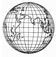
The Robinson Projection, designed by the National
Geographic Society
Maps have been made by humans for millenia. One of the oldest surviving maps of a town was found on the walls in a Stone Age settlement in what is now Turkey. It was made about 6,000 years ago. It shows houses and religious buildings and roads to other towns. (See The History of Maps) In about 200 BC, the ancient Greek geographer Eratosthenes was one of the first to create a map overlaid by a grid.
The Key to Exploration
Today scientists, geographers, and sailors still use a grid
system very similar to the one invented by Eratosthenes. Each point on
the grid has a number and corresponds to one particular point on the Earth. The
vertical lines are called meridians of longitude, whereas the horizontal lines are
called parallels of latitude.
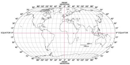
Latitude gives the location of a place north or south of the equator, whereas longitude locates a place east or wet. To give numbers to the points on this grid, everyone had to agree on a zero, or staring point.
For latitude, the great circle of the equator makes a perfect starting point, so it was designated the prime parallel, and latitude is expressed in measurements of 0 degrees at the equator to 90 degrees north or south to the poles.
For longitude, no convenient zero point (prime meridian) could be found, so much confusion resulted, as map makers chose conflicting starting points. In 1884, an international prime meridian was agreed upon, passing through the Greenwich Observatory in England. Longitude was and is measured from 0 degrees at the prime meridian to 180 degrees at the International Date Line.
(In regions around the equator, the distance between two meridians one degree apart is approximately 111.1 km. As the traveler approaches one of the poles, this distance shrinks dramatically. If an observer is standing on the North Pole, he could draw a circle in the snow that has a circumference of 1 meter. It would contain 360 degrees of meridians. At that latitude near the pole, the physical distance between two meridians one degree apart is 1m/360 or about 3 mm. The physical distance between meridians strongly depends on the latitude of the observer.)
Each degree of latitude and longitude is divided into 60 minutes, and each minute into 60 seconds. This allows us to assign an exact position to any point on the Earth.
By taking readings of the stars and the Sun, sailors can find their latitude and longitude, and find their position on the sea. Scientists, explorers, and geographers use them to make accurate maps of the locations and features of lands that they are investigating.
Why do scientist care about mapping? Today mapmakers and scientists use longitude and latitude to map out changes in the environment, in the location and extent of biomes, of animal populations, and patterns of weather and pollution. An entire school of geography, called biogeography, has grown up around the idea of mapping living systems.
Check Your Understanding (Circle one answer):
1. A latitude of 85 degrees would be
(far from the equator)(near the equator)?
2. A longitude of 180 degrees would
be (in England)(across the globe from England).
Advanced reading (below)
Latitude and Longitude:
The Age of Exploration, which began about 1,300 AD,
demanded a lot of information about distant locations to support travel and
trade. Portuguese navigators, then
later Spanish and English ships provided information about Africa, India, the
Americas, and the Far East to European nations. Russian navigators explored the Northern Pacific and North
American coasts, as well as the interior of Asia. Older maps did not commonly have a vertical and horizontal
grid overlaid on physical features.
Convention arose at that time to use a system of horizontal lines on the
globe called latitudes. The
longest of these parallels is the equator. It is a circle positioned midway between the north and south
poles. The parallel grid lines never meet, but they do get shorter in length as
they approach the poles. The second set of grid lines, perpendicular to the
parallels is called longitude. All
longitude lines meet at the north and south poles on the globe. Each point on
the earth can be accurately and uniquely specified by a latitude and longitude.
Cartographers agreed that the measurement of these grid
lines would be in degrees, not any physical measure like meters. Sailors navigated by the stars, which
had traditionally been measured using angular units. Navigators adopted the old convention of 360 degrees in a
circle for physical maps of the earth. There is a natural way to measure
latitude - angular distance up (north) or down (south) from the equator. The
North Pole is 90 degrees north of the equator and the South Pole is 90 degrees
south of the equator.
The convention for longitude was more difficult to
achieve; there is no natural way to start measuring meridians. English naval power became dominant
in this time and English maps grew in accuracy. The English maps based measurement of meridians by the
meridian that passed through the main street in Greenwich England and passed
through the middle of the Royal Astronomical Observatory there. Cartographers accepted the Greenwich
meridian as the zero point for all other meridians. Longitude is measured east or west of the Greenwich
meridian.
Because the earth is a sphere the number of kilometers
between parallels one degree apart must remain the same. The circumference of the earth is about
40,000 km. This means the physical
distance between two parallels one degree apart is 40,000/360 = approximately
111.1 km. The physical distance
between two meridians one degree apart is a more difficult question. In regions around the equator,
the distance between two meridians one degree apart is approximately 111.1
km. As the traveler approaches one
of the poles, this distance shrinks dramatically. If an observer is standing on the North Pole, he could draw
a circle in the snow that has a circumference of 1 meter. It would contain 360
degrees of meridians. At that latitude near the pole, the physical distance
between two meridians one degree apart is 1m/360 or about 3 mm. The physical
distance between meridians strongly depends on the latitude of the observer.