Where are We in the World? (teacher)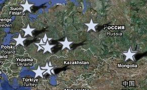 |
Overview Students consider the concept of location. Looking at a world map, they identify their lines (technically, angles) of latitude and longitude and use them to locate all Global Lab participants. ObjectivesStudents will: Classroom Management and PreparationBookmark the Global Lab Web site from which you can go to the Global Lab Map. Bookmark http://earth.google.com
|
Steps:
Ask your students to consider when it is important to know where they are located. When might it be important to be exact? (Imagine you are on a boat and trying to find the island of Tahiti, the destination of some early Polynesian explorers. How could you navigate?)
There are various strategies for this exercise. The shared GL step is location of your school on the web site map. This may already have been done by class time. Location on a large paper map or on individual maps is also an excellent exercise for students. Finally, using Googler Earth resources opens a gateway to rich investigations of local resources.
1. Have students locate the latitude and longitude lines (technically angles), and the coordinates of the other Global Lab sites. (These coordinates are located on each school's web page, which you can access by clicking their map site.) Ask students to place push pin or sticker on the world map or globe locating their class and other Global Lab classes. They should also maintain their own map page in their journal. Remind students that as they do so, Global Lab students around the world are placing map tacks on their own maps and that, in each class, one of the map tacks is for your school. |
Latitude implications: Temperature increases towards the equator. Why? Is this enough to explain the position of deserts? Biodiversity increases towards equator. Why? Could this be connected to the increase in temperature and biota, providing more niches for plants and animals. Time ZonesLongitude implications: |
EXTENSIONS:Investigate free maps such as those available here: http://www.graphicmaps.com/webimage/testmaps/maps.htm Take pictures of your area with various GPS apps, such as a cell phone with that capacity. RESOURCES Wikipedia has fine pages on the subject, including a List of Cities by Latitude. My World GIS Pasco produces this educational GIS produced by educators at Northwestern. It sells for $99, but can be used in a 45-day trial, during which time an extensive set of data can be mapped, and layered on the world map. |